|
Highway Planning 101
During each step, local planning staff with the Charlotte Regional Transportation Planning Organization, or CRTPO, and the North Carolina Department of Transportation, or NCDOT, evaluate and prioritize each project, which determines whether it moves on to the next step. Most steps include opportunities for public participation and input. These steps may include other transportation projects, such as rail, public transportation, bicycle, and pedestrian projects. The following discussion focuses on highway and other road projects in Steele Creek. Comprehensive Transportation Plan (CTP) The CTP "represents the Charlotte area’s long-term vision for how the transportation network should evolve to serve residents and employers." It includes projects that may be built 30 or more years into the future and is not limited by available or expected funding. The CTP has two major purposes:
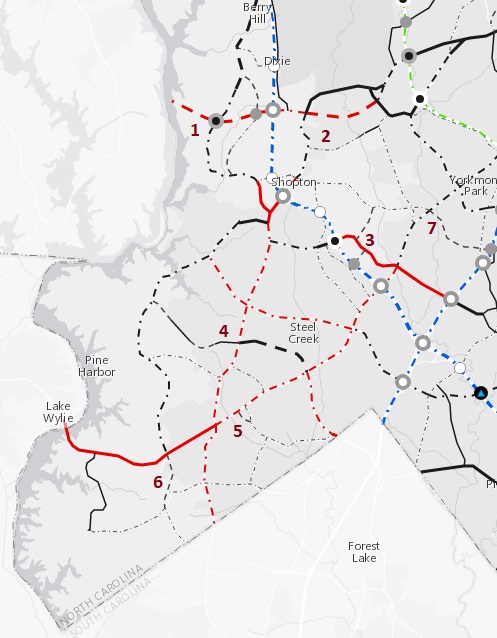
CRTPO reviewed and updated the local CTP in 2016 and approved the current CTP in January 2017. The North Carolina Board of Transportation adopted the CTP in March 2017. The CTP includes improvements to numerous roads within Steele Creek. It also includes the following new roads, which are numbered on the map below. See the full map HERE.
See also Opportunity for Public Involvement for Comprehensive Transportation Plan (July 26, 2016). Metropolitan Transportation Plan (MTP) The MTP includes projects for which revenue is expected to be available within the upcoming 25 years. CRTPO adopted the 2040 MTP in April 2014 and currently is preparing the 2045 MTP. Projects are prioritized and grouped by horizon years, which implies that there will be funding available to complete the projects by the horizon year. Horizon year 2025 includes projects that are already funded and scheduled for construction in the next few years. Additional future projects are listed under horizon years 2035 and 2045. CRTPO is accepting comments on the list of projects in its 2045 MTP through August 3. See Comment Period Open for Metropolitan Transportation Plan. Steele Creek projects being considered in the draft 2045 MTP are the following: Horizon Year 2025 (Existing and Committed in STIP)
There will be another opportunity for public input early in 2018, and CRTPO is scheduled to adopt the 2045 MTP in March 2018.
Prioritization is NCDOT's decision making tool that quantitatively evaluates projects to be considered for the next Transportation Improvement Program (TIP). CRTPO recommends projects, NCDOT scores the projects, and CRTPO applies local input points using a methodology that includes qualitative, quantitative, and local involvement components. During the comment period for Prioritization 3.0, CRTPO received 37 comments, of which about three fourths were in support of Highway 160 projects. Widening Highway 160 from Shopton Road West to Highway 49 and improvements to the Highway 160/Hamilton Road intersection received local input points from CRTPO, but the widening of Highway 160 from Highway 49 to the South Carolina state line did not. The Prioritization 3.0 process was completed in fall 2014. The Widening of Highway 160 from Highway 49 to the South Carolina state line was evaluated during the Prioritization 4.0 process two years later and scored well enough to move up to be on the same schedule as that part of Highway 160 north of Highway 49. Prioritization 5.0 is now underway. Projects have been identified for scoring, and the only highway project being considered in the Steele Creek area is the widening of I-77 to 10 lanes north of I-485. However, the Walker Branch Greenway between Steele Creek Road at Sledge Road and Smith Road is on the list of potential bicycle and pedestrian projects.
Statewide Transportation Improvement Program (STIP)
The STIP is a statewide
list of projects released by NCDOT that realistically can be funded within the
upcoming 10 years. Projects scheduled to begin right-of-way
acquisition or utility relocation in the first 5 years of the STIP
are considered committed and not subject to reprioritization.
Projects scheduled to begin after the first 5 years are subject to
reprioritization.
The Transportation
Improvement Program (TIP) includes the projects on the statewide
list within the local CRTPO area.
The current,
2016-2025
TIP lists two committed projects within Steele Creek:
The
widening of Highway 160 from Highway 49 to the South Carolina
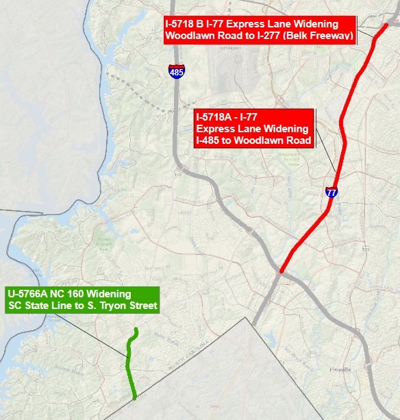
state line was not included on the 2016-2025 STIP. NCDOT
issued the initial draft 2018-2027 STIP in January 2017 and a
revised draft in June 2017. The draft STIP now includes the following:
NCDOT’s Board of Transportation will adopt the STIP in August,
and CRTPO will be required to adopt the 2018-2027 TIP by
September of 2017. CRTPO is accepting comments to the local
2018-2027 DRAFT TIP through August 9. See
Comment Period Open for Highway 160 Project.
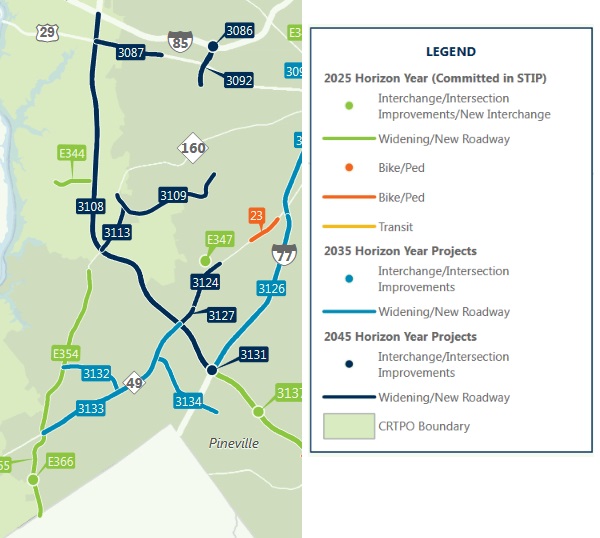
The map below shows
the projects in draft 2018-2027 STIP in southwestern Mecklenburg County. The map showing all
the projects in
Mecklenburg County can be viewed
HERE.
Steele Creek
residents will have opportunities to provide input in local projects as each of these
plans is updated in the future.
CRTPO has provided
the following video to explain the transportation planning process:
To comment on this
story, please visit the
Steele Creek Forum or the
Steele Creek Residents Association Facebook Page. |


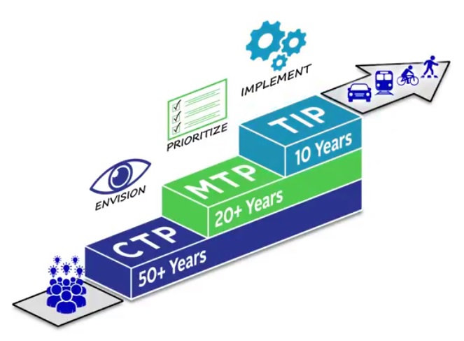 (July 28, 2017) In
Mecklenburg County, road
projects (including widening or otherwise improving existing roads
as well as constructing new roads) go through a series of planning
steps starting with a wish list (the Comprehensive Transportation
Plan, or CTP) and continuing through to having funding committed (in
the State Transportation Improvement Program, or STIP).
(July 28, 2017) In
Mecklenburg County, road
projects (including widening or otherwise improving existing roads
as well as constructing new roads) go through a series of planning
steps starting with a wish list (the Comprehensive Transportation
Plan, or CTP) and continuing through to having funding committed (in
the State Transportation Improvement Program, or STIP).