|
Rapid Steele Creek Population Growth is Expected to Continue
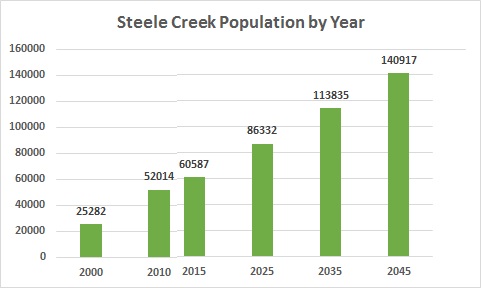
The 2010 census counts show that the population of Steele Creek increased by 26,732, or 106%, from the 2000 census count of 25,282. Mecklenburg County grew by 32% from 695,454 in 2000 to 919,628 2010, so Steele Creek had been growing at a rate three times that of the county as a whole during that decade. Estimates for 2015 show a slower rate of population increase from 2010 to 2015, but population is projected to increase by more than 25,000 in each of the next three decades. The population of Steele Creek is increasing because more people are moving in than are moving out. As any Steele Creek resident knows, many of our neighbors are moving south to York County, so the number of people moving into Steele Creek is even greater than the counts would suggest. The chart below shows the population of Steele Creek calculated from 2000 and 2010 census block counts, and population, housing, and employment counts tallied from estimates and projectsions by traffic analysis zones.
The map below shows population density by traffic analysis zones in Steele Creek. Traffic analysis zones are small areas used for transportation and other planning purposes. The estimates and projections in the table above were derived by summing the counts for the traffic analysis zones in Steele Creek. The green line on the map is the boundary for Steele Creek used by this web site. The northwestern boundary of Steele Creek follows the northern boundary of Steele Creek Township. Since traffic analysis zone boundaries do not use the township line, the counts for 2015 through 2045 cover a slightly larger area that this web site's boundary for Steele Creek. The map also shows the locations of residential addresses from Mecklenburg County's Master Address Table as of April 14, 2017. The map mirepresents apartment buildings and other multi-unit structures, since there is only one address point for each basic street address rather than one dot for each unit. The map clearly shows the nonresidential swath along Westinghouse Boulevard that splits Steele Creek's two major residential clusters. One residential cluster stretches from South Tryon Street through neighborhoods along Sandy Porter Road and Brown-Grier Road, continuing across Steele Creek Road to the Berewick neighborhoods. Planning is ongoing on how to develop the area bounded by I-485, Sandy Porter Road, Brown-Grier Road, and Steele Creek Road (excluding the school campuses) with residential and commercial uses. Areas northeast of I-485 likely will lose population as residential areas near the airport convert to industrial or office uses. Areas west of I-485 will see growth as part of the planned River District development, excluding the Berewick Regional Park. The other cluster is south of the Westinghouse industrial corridor, with the highest densities east of Shopton Road West and west of Carowinds Boulevard. Areas with potential for future development include the area south of Sledge Road and the area southeast of RiverGate. Areas west of Shopton Road West (excluding McDowell Nature Preserve), Youngblood Road, and Zoar Road have lower densities and have potential for growth.
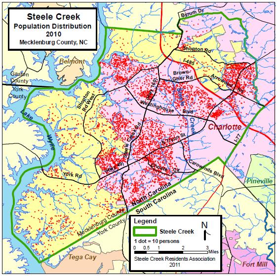
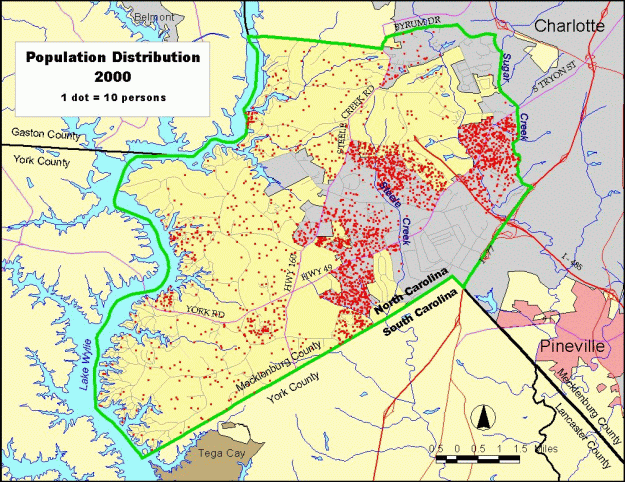
The two maps below show population distribution based on census block counts from the 2000 and 2010 censuses, with each dot representing 10 persons.
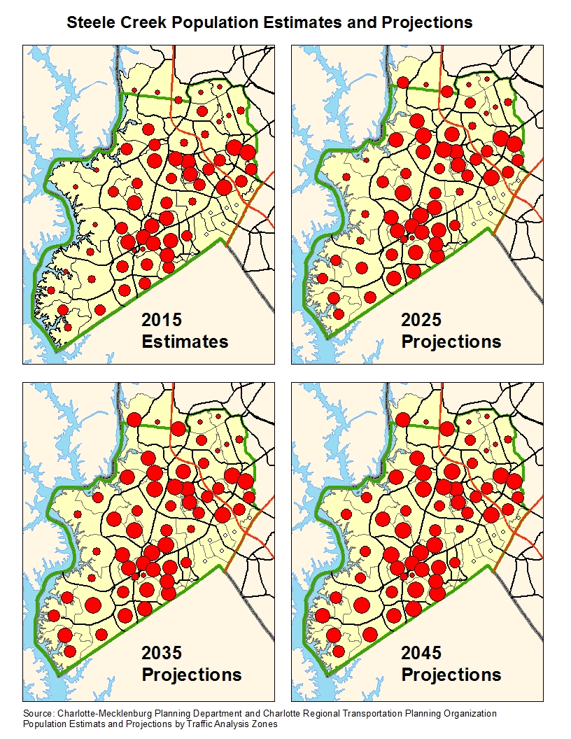
The four maps below show the population estimates (2015) and projections (2025-2045) for traffic analysis zones in Steele Creek. The 2015 estimate forms the basis for the projections.
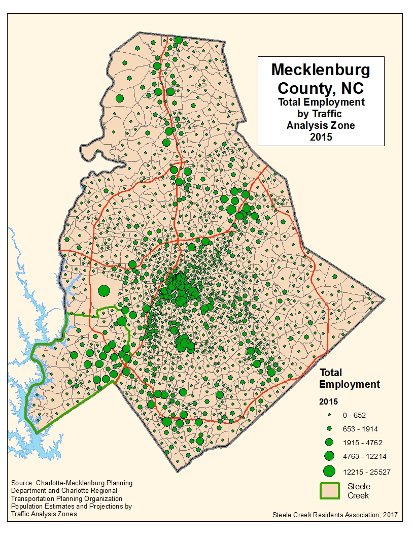
Employment estimates for 2015 show more workers in Steele Creek than residents, which is not surprising since the Westinghouse coridor is one of the major employment centers in the county. Projections show a greater rate of increase in population than employment, but the projections may not factor in the amount of additional industrial and office development expected in the area south of the airport. It has been said that the Westinghouse industrial corridor is the second largest employment center in Mecklenburg County behind Uptown. However, the University City area also has significant employment. The determination of which is larger depends on what traffic analysis zones are included in each area, but it appears that the Westinghouse corridor has a few thousand more workers. Nonetheless, Steele Creek Residents are well aware of the heavy traffic patterns on I-485 heading into Steele Creek in the mornings and out of Steele Creek in the afternoons.
Steele Creek is
developing rapidly and still has enough vacant land for the
population and employment to continue growing over the next three
decades.
Click here:
|
||||||||||||||||||||||||||||||||||||||||||||||||||||||||||||||


 (April 24,
2017) According to estimates compiled by the Charlotte-Mecklenburg
Planning Department and the Charlotte Regional Transportation
Planning Organization, the population of Steele Creek was
60,587 in 2015, an increase of 8,573 over the 2010 census count of 52,014.
They project Steele Creek's population to increase to 140,917 by
2045.
(April 24,
2017) According to estimates compiled by the Charlotte-Mecklenburg
Planning Department and the Charlotte Regional Transportation
Planning Organization, the population of Steele Creek was
60,587 in 2015, an increase of 8,573 over the 2010 census count of 52,014.
They project Steele Creek's population to increase to 140,917 by
2045.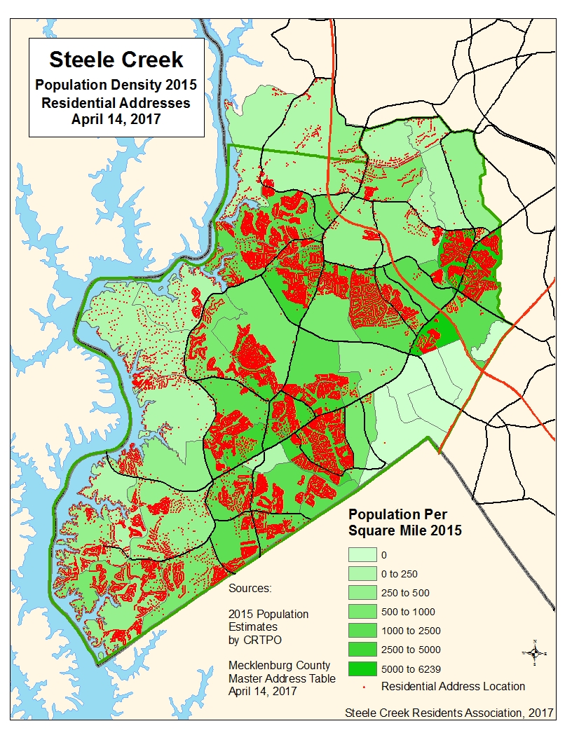
 Projections are based
primarily on Community Type Category (Industrial, Single Family,
etc), Development Status of Land (Undeveloped, Underdeveloped,
Developed), and attraction factors. However, they don't always
reflect actual conditions. For example, traffic analysis zone #1831
(northeast of I-485 and northwest of Steele Creek Road) shows a 2015
estimate of 263 and a 2045 projection of 4512. This would seem
logical based on the fact that it is primarily single family
residential and is mostly undeveloped or underdeveloped. But the
airport is in the process of buying the homeowners out and has plans
to convert this area to industrial. It is more likely to decrease in
population than increase 1600%. Projections for individual traffic
analysis zones may be inaccurate if local factors are not taken into
consideeration, but generally this should be a good indicator of
where and how much growth should occur over the next 30 years.
Projections are based
primarily on Community Type Category (Industrial, Single Family,
etc), Development Status of Land (Undeveloped, Underdeveloped,
Developed), and attraction factors. However, they don't always
reflect actual conditions. For example, traffic analysis zone #1831
(northeast of I-485 and northwest of Steele Creek Road) shows a 2015
estimate of 263 and a 2045 projection of 4512. This would seem
logical based on the fact that it is primarily single family
residential and is mostly undeveloped or underdeveloped. But the
airport is in the process of buying the homeowners out and has plans
to convert this area to industrial. It is more likely to decrease in
population than increase 1600%. Projections for individual traffic
analysis zones may be inaccurate if local factors are not taken into
consideeration, but generally this should be a good indicator of
where and how much growth should occur over the next 30 years.