|
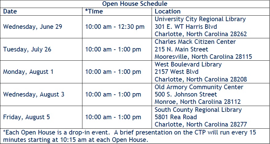
(July 26, 2016) The Charlotte Regional Transportation Planning Organization (CRTPO) is now accepting comments to its Comprehensive Transportation Plan (CTP), which identifies potential future transportation projects in the Charlotte region. CRTPO will adopt an updated plan later this fall. The public can provide feedback at Open House Events, including Monday, August 1 at West Boulevard Library and Friday, August 5 at South County Library (see Schedule), or through the Interactive Mapping application. Additionally, CRTPO will be conducting two webinars about CTP. The webinar format will allow viewers to learn more about the CTP without having to travel to meeting sites. The first webinar will be held this Friday, July 29 at 9:00 AM. Access information is listed below. Those unable to participate on Friday will have another webinar opportunity on August 18. The content of both webinars will be the same.
CRTPO has not announced an end date for accepting comments but anticipates adopting an updated plan later this fall. Before road and other transportation projects can be built, they have to go through planning and prioritization processes. The major agencies involved in these processes for Steele Creek projects are the Charlotte Regional Transportation Planning Organization (CRTPO), The North Carolina Department of Transportation (NCDOT), the Charlotte-Mecklenburg Planning Department, and the Charlotte Department of Transportation. Four major processes are as follows:
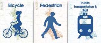
Interactive Mapping You may use the Interactive Mapping application to comment on Highway, Bicycle, Pedestrian, and Public Transportation & Rail projects. The applications do not work well with Internet Explorer or Firefox. They seem to work well with Google Chrome or Microsoft Edge. Each application has a map showing existing or proposed transportation features, or those that need improvement. Zoom in by clicking on the + in the upper left of the map and dragging the map to the area you want, or by pressing the shift key and drawing a box to zoom in to an area. There is also a search function. Slide the "Filter list by map" switch in the upper right to display a list of features within the visible map. Select a road or other feature by pointing and clicking on it on the map. You must be right on the feature, so you may need to try several times. You may also select a feature from the list. Be aware that several road segments may be listed separately. You may need to click on different names before you get to the segment you need. The map will zoom in to the feature and provide information on the right. Note that some of the Planning Source links are not valid. If you like a project, click on the heart icon If you would like to comment on a project, click on the
speech bubble icon
To return to the list, click on the < symbol to the left of the green band containing the feature name.
The Highway application shows a variety of road projects in Steele Creek. The map also shows interchanges, but these aren't selectable.
1) The map still shows Garden Parkway although NCDOT is no longer planning to build this highway. Instead, developers are proposing a new development here called River Place. Their plans include new roads that will provide access to a possible new bridge across the Catawba River. Their plans also affect future routes for Dixie River Road and Garrison Road. 2) The map shows a new connection between Douglas Drive and Pine Oaks Drive. 3) The map shows a new road between Arrowood Road and Shopton Road. It also shows a new road passing over I-485 connecting Arrowood Road with Whitehall Park Drive.
4) The map shows a new extension of Carowinds Boulevard. A new road would run from South Tryon Street around the north side of The Crossings to connect with the existing Sam Neely Road. There would be another new segment running from Sam Neely Road through Planters Walk connecting with Winget Road along a path that had been left undeveloped in anticipation of a new road. Finally there would be another new segment connecting the end of old Winget Road to the end of new Winget Road through Chapel Cove at Shopton Road West. This road was originally identified as a need when what later became the Sanctuary was rezoned for 100s of houses that were not built. Is this road still needed? Could the reserved path through Planters Walk be used for another purpose? 5) The map shows a new road connecting Choate Circle at the Steele Creek Athletic fields to South Tryon Street and Corsica Forest Drive. This new road would run on the southwest side of the Calloway Glen Townhomes. 6) The map shows an extension of Shopton Road West running south from York Road to Zoar Road. This road would replace Youngblood Road. 7) The map shows a new road running east of South Tryon Street at Shopton Road connecting to Nations Ford Road and Archdale Drive. Additionally, most other major roads in Steele Creek are classified as either boulevards, other major thoroughfares, or minor thoroughfares. Most are further classified as "Needs Improvement." Are the thoroughfare classifications appropriate? (Shopton Road West, for example, is classified as a minor thoroughfare. Should it be upgraded?) Do some of these roads need improvement sooner than others? Are other new roads needed?
The Bicycle map shows on-road bicycle routes as well as greenway trails. Are some of these needed more and sooner than others? Pedestrian The Pedestrian map shows sidewalks as well as greenway trails. Are some of these needed more and sooner than others? Public Transportation & Rail The bus routes shown do not appear to be current. For example, the map still shows the route along Brown-Grier Road and Whitehall Park Drive even though this was rerouted to the outlet mall over a year ago. The list does not have bus route numbers or road names, just "Existing Bus Route" and "Recommended Bus Route." Future transportation projects will come from those identified on the Comprehensive Transportation Plan. Enen though construction may be years away, it is important that transportation needs be identified now. This is your opportunity to identify needs that the planners may have overlooked or deemed unneeded.
To comment on this story, please visit the Steele Creek Forum or the Steele Creek Residents Association Facebook Page. |


 .
The counter in the upper right will record your like.
.
The counter in the upper right will record your like. .
Your comments may or may not appear below in the comments section.
They may appear after you hit Submit but not be there when you revisit the page. CRTPO
staff have given assurances that the comments are being recorded and
saved.
.
Your comments may or may not appear below in the comments section.
They may appear after you hit Submit but not be there when you revisit the page. CRTPO
staff have given assurances that the comments are being recorded and
saved.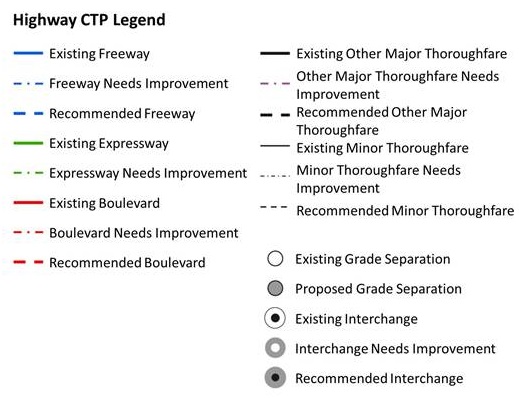 Note
the following roads numbered on the map below in maroon:
Note
the following roads numbered on the map below in maroon: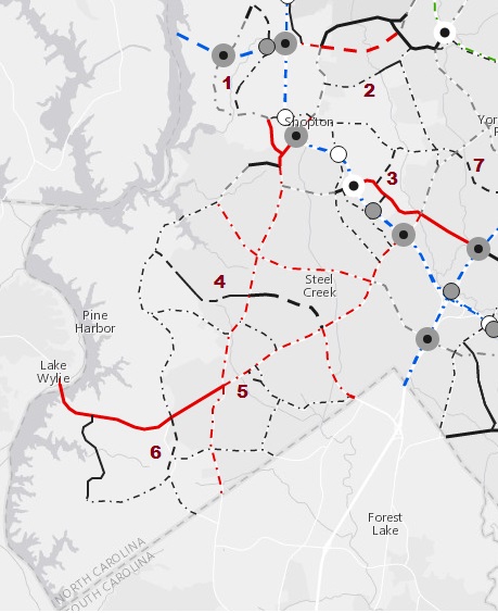
 Bicycle