|
STEELE
CREEK NEWS
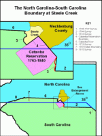
(Click HERE to see a larger map of the boundary.) The present boundary between the two states resulted from four major disputes and six surveys over a period of almost a hundred years. The boundary expanded step by step from the Atlantic Ocean into the Appalachian mountains roughly following the spread of population inland. It was based on an agreement made in 1735 that would have placed most of the boundary following the 35th parallel of latitude, but instead the line zigzags back and forth. Errors and delays induced disputes and uncertainty along the boundary until it finally reached 35º at the western terminus of the boundary at the Chatooga River. Although a single Colony of Carolina was established in 1663 when King Charles of England issued the colony's charter to eight proprietors, North Carolina and South Carolina were soon functioning separately. By 1665 the Governor of Virginia had established a government north of Albemarle Sound in the new Carolina Colony. Settlement began at Charles Town in 1670 where a separate government was established. The two colonies formally were separated in 1729 when the king purchased the colony from the proprietors. The boundary between the two colonies was generally understood to be at Cape Fear, although North Carolina was granting land west of the river. In 1730 newly appointed royal governors agreed on a boundary that would begin a point 30 miles west of the mouth of the Cape Fear River and continue inland parallel to the river. Under certain conditions, the boundary would follow the Waccamaw River. Once the governors got to the New World they discovered that the boundary decision was too ambiguous and difficult to implement. Each colony appointed commissioners who met in April 1735 and agreed to a new boundary definition. The boundary was to begin 30 miles west of the Cape Fear River as agreed previously, but it was to run to the northwest until it reached 35º latitude and then continue west to the South Seas. The agreement also called for adjustment if necessary to include lands of the Cherokee and Catawba Indians in South Carolina. Georgia was created in 1732 from that part of South Carolina west of the Savannah River. This boundary eventually followed the Chatooga River, a northern tributary of the Savannah River. The 1735 boundary agreement effectively cut South Carolina off from western territory to North Carolina's benefit. Once all boundaries of the two states were finally set in the 1820's, North Carolina wound up with approximately 60 percent more land area than South Carolina. A survey was begin soon after the 1735 agreement and completed in 1737 when surveyors stopped at what they believed to be 35º latitude. (Line 1 on map.) Settlement soon outran the boundary, resulting in overlapping land grants and confusion. In 1763 the Board of Trade in London instructed the two colonies to extend the 1735-1737 line to 35º if it had not been done so and then due west to the lands of the Catawba Indians. In 1764 commissioners from both states continued the boundary westward from the terminus of the 1737 survey to a point on the Salisbury Road, a few miles from the Catawba Reserve, which had been established a few months earlier. (Line 2 on map.) What the commissioners didn't realize was that they actually were 13 miles south of the 35th parallel, resulting in a loss for South Carolina of about 800 square miles. South Carolina realized the error a few years later and proposed a western boundary that would compensate that colony for the loss. They proposed a boundary that began at the end of the 1764 survey and followed the Salisbury Road north to the boundary of the Catawba Reserve. it would then follow the boundary around the north side of the Catawba Reserve to the Catawba River and then follow the Catawba River to its source. North Carolina wanted the line surveyed in 1764 to be continued due west. In 1771 the Board of Trade in London ordered a compromise. The boundary would follow the South Carolina proposal to the Catawba River. It would go up the river to the confluence of the north branch (currently the Catawba River) and south branch (currently South Fork) and then due west to the Cherokee Boundary of 1767. This boundary was run in 1772. (Lines 3, 4, 5, and 6 on map.) Thus the portion of the state line established in 1772 set the southern boundary of Mecklenburg County's Steele Creek community along the Catawba Reserve boundary, which was established in 1763. The Catawba Reserve was 15 miles square, or about 225 square miles. (Some descriptions state that it was 15 square miles rather than 15 miles square, a gross understatement of the reserve's size.) South Carolina granted the land to the Catawbas in a 1760 treaty. A boundary survey was begun in 1762 and the reserve was formally approved at the Southern Indian Congress in Augusta, Georgia in 1763. Although South Carolina granted land for the reserve to the Catawba Indians, North Carolina also had been granting land in the area within and west of the Catawba Reserve since before 1772. Portions of this area east of the Catawba River were administered as part of Mecklenburg County and those west of the Catawba River were administered as part of Tryon County. South Carolina referred to the area gained in the 1772 survey as the New Acquisition until it established counties in 1785. The current southern boundary of York County, South Carolina is a western continuation of the 1764 line. Although the 1735 agreement called for the boundary to follow the 35th parallel, the Board of Trade chose not to change the boundary surveyed in 1764 and to place the boundary to the west where it would compensate South Carolina for their loss caused by previous errors. The portion of the 1772 boundary surveyed west from the Catawba River ran slightly north of due west and is another example of the errors made along the boundary. It ended at the Cherokee boundary that North Carolina had surveyed in 1767 (line 7 on the map) and was the western limit of European settlement at the time. North Carolina refused to accept the 1772 survey and insisted on a resurvey along the 35th parallel. It continued to protest until 1808 when a review of the original 1735 agreement revealed that South Carolina could legally claim all Cherokee lands, which covered significant areas in the west, including most of the future state of Tennessee. In 1808 commissioners from the two states accepted previously established boundaries except one and came to agreement on the final section of the boundary. They agreed that the portion of the boundary following the Salisbury Road should be resurveyed as a straight line between the end of the 1764 survey and the western corner of the Catawba Reserve. This survey was completed in 1813 and forms a portion of the current boundary between Union County, North Carolina and Lancaster Country, South Carolina. (Line 3 on map.) (Andrew Jackson was born near this section of the boundary in 1767, although disagreement exists concerning the side of the line where his birth occurred. But that is another story.) The commissioners also agreed to a continuation of the boundary to the west following a straight line from the end of the 1772 survey to a point where the 35th parallel crossed the Appalachian Divide. After taking a closer look at the geography of the area, commissioners decided to place much of the boundary along a mountain ridge and end it at a point on the Chatooga River where they had determined that it crossed the 35th parallel. This line was surveyed in 1815, finally reaching the parallel in the original 1735 agreement. (Line 8 on the map.) South Carolina includes approximately 1300 square miles of territory north of the 35th parallel. The 1735 agreement eventually became the basis for the boundary between North Carolina and Georgia as well as the boundaries between Tennessee and the states of Mississippi, Alabama, and Georgia. The boundary between North Carolina and South Carolina is taken for granted today, but if decisions concerning the boundary had been different or if surveyors had not made the errors they did, the boundary could have looked quite different. |