|
STEELE
CREEK NEWS
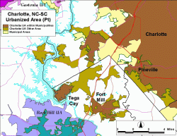
For Census 2000, UAs consist of contiguous, densely settled census blocks and block groups that meet minimum population density requirements, along with adjacent densely settled blocks that together have a total population of at least 50,000. Urban clusters (UCs) are defined in a similar manner and have a total population of at least 2,500 but less than 50,000. The Census Bureau classifies all area and population within UAs and UCs as urban and all area and population outside UAs and UCs as rural. Many federal and state agencies use Census Bureau-defined urban and rural classifications for allocating program funds, setting program standards, and implementing aspects of their programs. The Census Bureau identifies urban and rural areas only for the presentation of census statistical data. If other agencies use these areas in nonstatistical programs, it is the responsibility of those agencies to ensure that the results are appropriate for such use. See the Census Bureau's web page on Census 2000 Urban and Rural Classification for more information on national UA and UC definitions and criteria. The specific areas included in UAs are identified through an automated process that examines population density, contiguity, and distances across small gaps called hops and jumps. The program "first looks at the shortest road connection, and then picks the blocks along that road connection that creates the highest overall density," says Dave Aultman, UA project team leader with the Census Bureau's Geography Division. UAs can include areas both inside and outside municipalities, and the criteria are intended to provide consistent definitions from state to state so that varying incorporation and annexation policies have minimal impact on the urban/rural classification. As a result of the delineation process, the Charlotte UA snakes through Steele Creek and crosses Lake Wylie into South Carolina to the west. It also heads south into South Carolina to the west of Carowinds and forks out to take in Tega Cay and most of Fort Mill. (For the 1980 and 1990 censuses, Fort Mill was in the Rock Hill UA.) The delineation process objectively looks at connectivity and does not distinguish between major highways and back roads or between direct connections or indirect, roundabout routes. On the maps, the darker brown areas are portions of the Charlotte UA within municipalities. The lighter brown areas are areas within the UA that are outside municipalities. The yellow areas are within municipalities but outside the UA. Some parts of Charlotte are classified as rural because of their low population density even though they are urban in character, such as the industrial areas along Westinghouse Boulevard and Beam Road. The Steele Creek area map and the larger, full Charlotte UA map also show portions of the Concord, Gastonia, and Rock Hill UAs. The Federal Highway Administration uses Census UAs in many of their programs. See their web page on Frequently Asked Questions Applying 2000 Census Data to Urbanized and Urban Areas in the FTA Planning Programs and FHWA Programs. The current Mecklenburg-Union Metropolitan Planning Organization includes all areas within the 1990 Charlotte UA and its structure may change as a result of the new UA. |


