|
|
|
STEELE
CREEK NEWS
Census Shows Uneven Population Distribution in Steele Creek
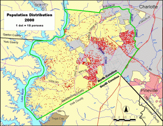 (February 1, 2002) According to
census results, Steele Creek's population was 25,282 in April
2000. With an area of about 47 square miles, the overall population density was over 500 persons per square mile, but this was not distributed evenly throughout the area.
Click HERE to see a larger version of the population
distribution map. (February 1, 2002) According to
census results, Steele Creek's population was 25,282 in April
2000. With an area of about 47 square miles, the overall population density was over 500 persons per square mile, but this was not distributed evenly throughout the area.
Click HERE to see a larger version of the population
distribution map.
The census showed a population of 15,954 in that portion of Steele Creek within Charlotte in 2000. City planners estimated the population of the area annexed in 2001 at 2,323, which means that over 18,000
persons or approximately 72% of Steele Creek's population was within the City of Charlotte. The area within Charlotte comprises only about one third of the total area and had a population density of over 1,1500 persons per square mile.
Most of the Steele Creek population is located in three concentrations. Residential areas along South Tryon Street between Sugar Creek and Arrowood Road in northeast Steele Creek had a 2000 population of 5,502. A second concentration of neighborhoods along Sandy Porter Road and Brown-Grier Road had a population of 5,134. Finally, areas located on either side of South Tryon Street west of Steele Creek down to Erwin Road, including Yorkshire and The Crossings, had a population of 7,376. These three areas totaled 18,002 in 2000, which is 71% of the Steele Creek total.
As would be expected, industrial areas have little population. These include the Arrowood Business Park and other areas along Westinghouse Boulevard and the Beam Road.
Most of the remainder of Steele Creek has a much lower population density, which was less than 250
persons per square mile.
Of course, this has changed since the census was taken in 2000 as new subdivisions, townhouse developments, and apartments have popped up all over the area. Change is occurring rapidly and will continue to do so in upcoming years.
|