|
|
|
STEELE CREEK NEWS
Steele Creek
Township Shrinks as Charlotte Annexes
(March 6, 2009)
Steel Creek Township was established under the North Carolina
Constitution of 1868. Townships in North Carolina originally elected
Justices of the Peace and performed other governmental functions,
including maintaining roads and assessing property for taxation. In
1895 townships were stripped of their powers but remained as
administrative areas.
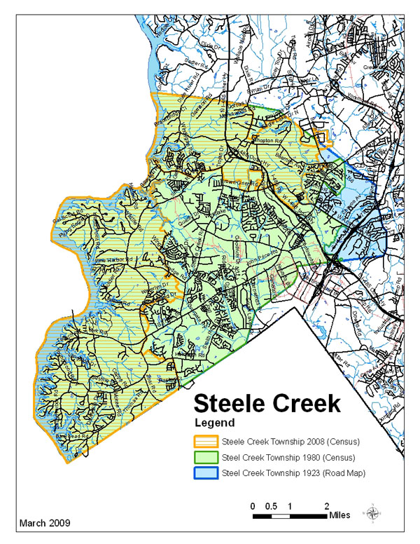
A Road Map of Mecklenburg County from 1923 that is available on the
Steele Creek Historical and Genealogical Society web site
shows Steel Creek Township (with one less "e" in its name).
The map below shows the 1923 boundaries of Steel Creek Township on a
modern road map base. The green and blue shaded areas are the 1923
township. The green area is Steel Creek Township as shown on 1980
census maps. The blue area is that part the original Steel Creek
Township that had been annexed by the City of Charlotte by 1980.
The City of Charlotte is its own township. When Charlotte annexes,
area automatically is removed from its original township and added
to the Charlotte Township. On Census maps, it's called "Township 1,
Charlotte."
It's interesting to note that the area around Carowinds and the
I-77/Westinghouse Boulevard interchange was in Pineville Township
rather than Steel Creek Township.
Up until
recently, census maps have shown the name as "Township 3, Steel
Creek." Mecklenburg County submitted a correction to the Census
Bureau a few years ago, and the name now appearing in census records
is "Township 3, Steele Creek." The spelling apparently changed from
Steel Creek to Steele Creek early in the 1900's.
The area shown with orange crosshatching is Steele Creek Township as
of January 1, 2008 according to current census records. This will
shrink further on June 30, 2009 when Charlotte annexes parts of
Berewick and adjacent areas.
The boundaries for the 1923 township on the map above were
delineated by taking the 1980 census boundaries and extending them
straight eastward to Nations Ford Road. The southern line on this
map that runs through the I-77/I-485 interchange is at a different
angle than the same line on the 1923 Road Map. This line also hits
Nations Ford Road just north of a sharp curve that doesn't appear on
the 1923 map. The curve is at the location of the Vulcan Materials
quarry, and Nation's Ford Road has been moved from its 1923
alignment to avoid it.
This map also is available in pdf format here:
Steele Creek Township
Do you have
information that would confirm or dispute these boundaries? If so,
post your comments on the
Message Board or sent them to
info@steelecreekresidents.org.
|