|
Just Where is Steele Creek?
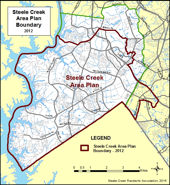
A web site about the Steele Creek community needed to have a map showing where that community was and what its boundaries were. The boundaries should also follow census tabulation boundaries so that census counts could be calculated. In 2002, when this web site was created, the only guidance provided was that Steele Creek was south of the airport and west of I-77. Western (Lake Wylie) and southern (the state line) boundaries were easy, as was I-77 to the southeast. On the northwest, it seemed appropriate to use the Steele Creek township line from Lake Wylie east to Steele Creek Road, but annexations had mostly erased the township line elsewhere. Byrum Drive and Yorkmont Road were convenient boundaries on the northeast, and Sugar Creek provided a nonresidential break between residential areas along South Tryon Street south of Shopton Road and the apartment neighborhoods further east along Tyvola Road. This boundary ensured that Steele Creek Presbyterian Church, Steele Creek AME Zion Church, and residences on the north side of Shopton Road were included. The map below shows the boundaries of Steele Creek that were chosen on 2002 (mostly) and continue to be used by this web site. Click HERE to view a PDF of this map.
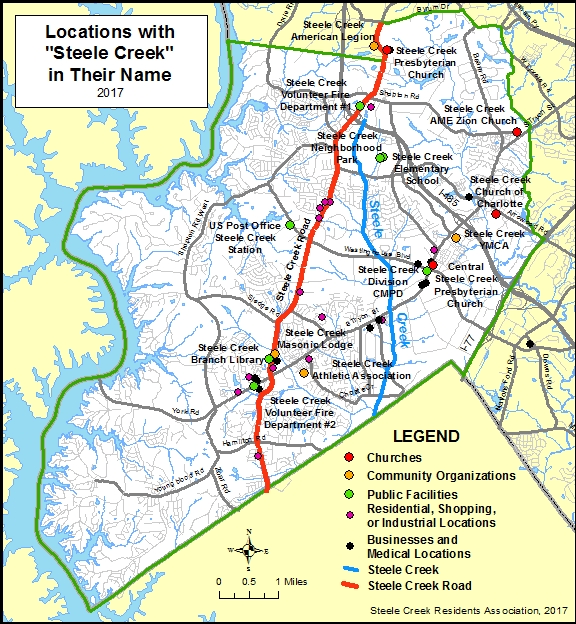
The area within this boundary is about 46 square miles. The area's Census 2000 population was 25,282, but by 2010 the population had increased to 52,014 according to the 2010 Census. The population in 2016 is probably around 60,000. Most of Steele Creek and its population is within the Charlotte city limits. But is this boundary an accurate depiction of Steele Creek? One way to evaluate it is to look at specific locations that have "Steele Creek" in their names, starting with the creek itself. Steele Creek's source is in the Steele Creek Place industrial park north of I-485 at Steele Creek Road. The creek flows through the center of the community and into South Carolina, where it contines through the Anne Springs Close Greenway and eventually flows into Sugar Creek. Steele Creek Road (North Carolina Highway 160) is another prominent feature crossing through the center of the community. The map below shows other key locations that include "Steele "Creek" in their names.
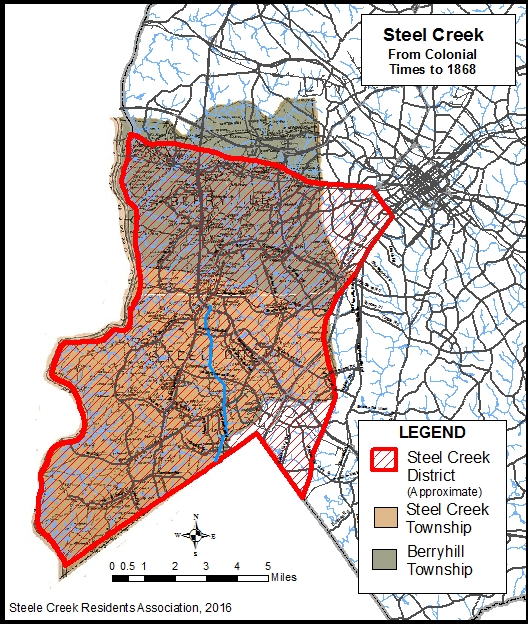
The first use of the name after the creek likely was by the Steele Creek Presbyterian Church, which was organized in 1760 and was one of the first seven Presbyterian churches of Mecklenburg County. Central Steele Creek Presbyterian Church was established in 1893 at its current location with the merger of Blackstock Presbyterian Church (formerly Steele Creek Associate Reformed Presbyterian Church (1793)), located off what is now Carowinds Blvd., and Little Steele Creek Associate Reformed Presbyterian Church (1809), located on Sandy Porter Road. Other current churches are Steele Creek AME Zion Church and Steele Creek Church of Charlotte. Update 2/13/2021: In 2019 Steele Creek Presbyterian Church and Pleasant Hill Presbyterian Church merged after the Charlotte Douglas Airport purchased the Steele Creek Presbyterian Church building and most of the property. The new church is called Steele Creek Presbyterian Church at Pleasant Hill and meets at the former Pleasant Hill Presbyterain Church location on York Road. The old Steele Creek Presbyterian Church Cemetery at the original church's location still belongs to the merged church. Community organizations include Steele Creek American Legion, Steele Creek YMCA, Steele Creek Athletic Association and Steele Creek Masonic Lodge. The Masonic Lodge formerly was located further north until it was displaced by the Berewick Town Center. Public facilities include Steele Creek Volunteer Fire Departments 1 and 2, Steele Creek Neighborhood Park, Steele Creek Elementary School, the office of Steele Creek Division of the Charlotte-Mecklenburg Police Department, Steele Creek Station of the United States Post Office, and the Steele Creek Library. The current Steele Creek Library opened in 2004. Previously it had been located in Steele Creek Commons Shopping Center at the corner of S Tryon Street and Sandy Porter Road. The purple dots on the map represent neighborhoods (mostly apartment complexes but including Steele Creek subdivision), shopping centers (Steele Creek Commons and Steele Creek Crossing), and an industrial park (Steele Creek Commerce Park). The black dots represent businesses or medical facilities with "Steele Creek" in their names, including Carolinas Medical Center Steele Creek. It does not include chains that include a location in their name, such as Home Depot Steele Creek, which are numerous. It is apparent from the map that the name "Steele Creek" is used in place names throughout the community boundaries, especially along main thoroughfares of South Tryon Street/York Road and Steele Creek Road. The only places outside the boundary are the Steele Creek American Legion across from Steele Creek Presbyterian Church and Steele Creek Printing and Design on Downs Road. To view a list of all 42 places on the map, click HERE. According to Linda Blackwelder's History of Steele Creek (unpublished), the Steele Creek area had been recognized by name since colonial times, although the spelling left off the final "e" in Steele until the early 1900's. Initially Steel Creek District consisted of a wedge of southwestern Mecklenburg County spreading out from Charlotte. Its northern boundary was slightly north of present-day Wilkinson Boulevard, and its eastern boundary generally followed today's South Tryon Street, Camden Street, Nations Ford Road, Kings Branch, and Sugar Creek. Steele Creek District generally was replaced by Berryhill and Steel Creek Townships where the state created townships following the adoption of the new North Carolina Constitution in 1868. On the map below, a modern street map of Mecklenburg County has been superimposed on a map published in 1911 showing Berry Hill and Steel Creek Townships. To view the original map of Mecklenburg County North Carolina 1911 by C. A. Spratt and J. B. Spratt, click HERE.
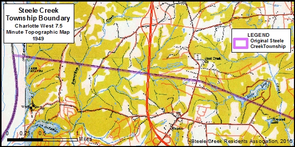
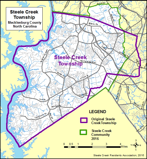
It is difficult to determine a precise boundary for the original Steele Creek Township since areas have been removed from the township as Charlotte has annexed into it beginning in 1973, and the original boundaries have not been maintained on modern maps. Roads and other features on modern maps do not line up well with those on older maps because the older maps are not as positionally accurate and contain fewer roads to match with. The township boundary on the map below was derived from the Charlotte West 7.5 minute topographic map dated 1949 and the Charlotte 15 minute topographic map dated 1907. As the map below shows, the township boundary extended east to Nations Ford Road, but that area is not considered part of the Steele Creek community today.
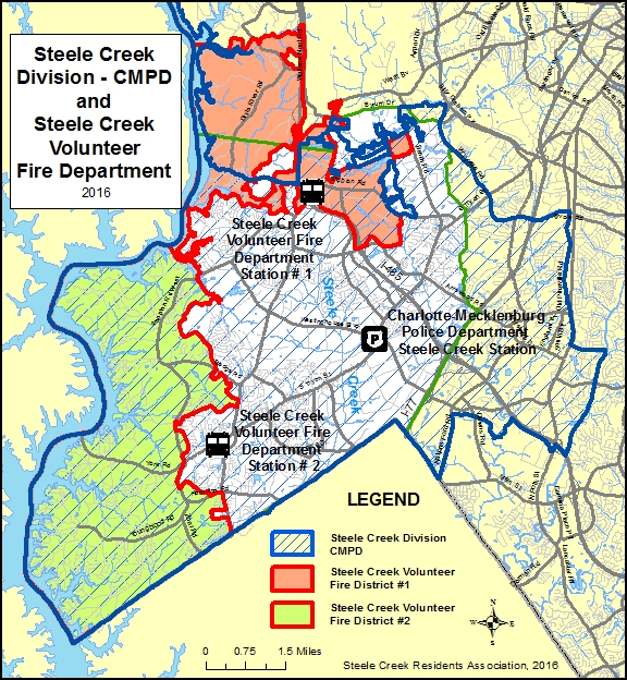
The Steele Creek Station of the Charlotte-Mecklenburg Police Department sits on the corner of South Tryon Street and Westinghouse Boulevard, at the central point on Steele Creek's main thoroughfare. The boundaries of Steele Creek Division extend eastward to Old Pineville Road and Little Sugar Creek. The division also includes the Lake Wylie Lake Patrol, which covers Lake Wylie all the way north to Mountain Island Dam. It excludes city-owned property near the airport, which is included in the Airport Division. However, the division boundaries were not chosen to represent the Steele Creek community. The division boundaries existed before the Police Departments selected names for its divisions. The division actually covered a larger area, especially to the north, before additional divisions were created. Steeleberry Volunteer Fire Department was chartered in 1954 to serve Steele Creek and Berryhill Townships. It became Steele Creek Volunteer Fire Department in 1959. Its first station was built on Steele Creek Road between Shopton Road and Shopton Road West. Steele Creek Station #2 is located on South Tryon Street west of Steele Creek Road. It once had a third station on Arrowood Road. The Volunteer Fire Department District has shrunk as Charlotte has annexed into it, but it still covers unincorporated areas of the old Steele Creek Township as well as part of Berryhill Township.
At least three schools have had the name Steel Creek or Steele Creek.
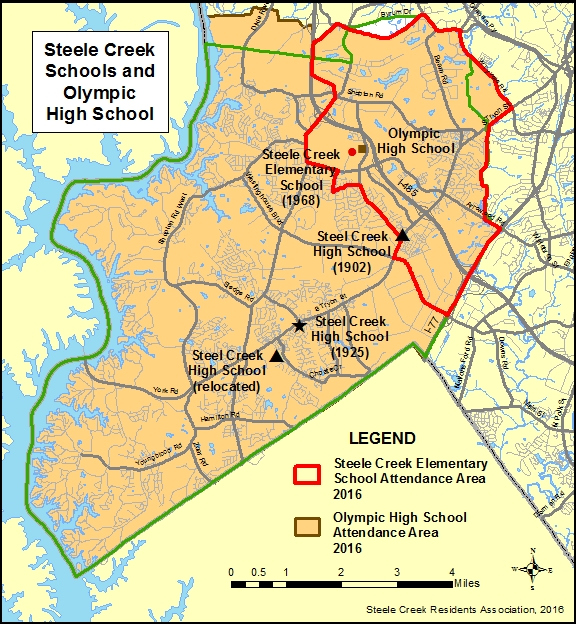
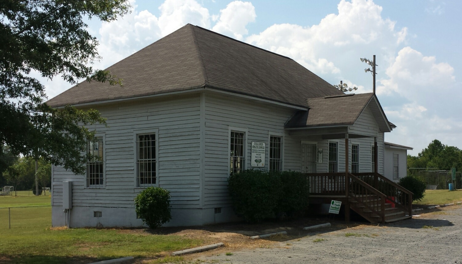
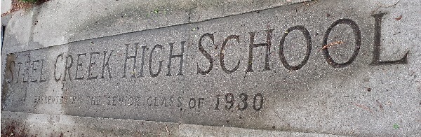
Steel Creek High School opened in 1925 on York Road (now South Tryon Street) at Erwin Road at the current site of Lions Gate Townhomes. At some point after 1931 area high school students began attending Berryhill High School to the north. This school served white students from throughout Steele Creek except for the northwestern part around the Shopton community. Although this school was torn down after 1968, the original school bell and the sign presented by the 1930 graduating class were preserved. The bell is now in the bell tower in front of the current Steele Creek Elementary School, and the sign was embedded in the sidewalk The current Steele Creek Elementary School opened in 1968. Its attendance area approximated that of the school it replaced but has become smaller as Lake Wylie Elementary School and other schools have opened. Now its attendance area includes the northeastern portion of the Steele Creek community. The Olympic High School attendance area is almost identical to that of the Steele Creek community.
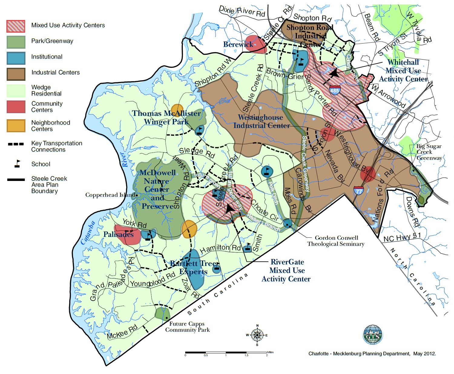
The Charlotte City Council adopted the Steele Creek Area Plan in 2012, which forms a framework for future development. The area plan boundaries exclude northern portions of the Steele Creek community. including Berewick, Olde Whitehall, and other neighborhoods off South Tryon Street north of Arrowood Road, but the boundaries were not selected in an effort to define Steele Creek. Instead the boundaries simply include area that had not been included in previous, adjacent area plans. According to the plan's Executive Summary, the area within its boundaries had a population of 35,000, about 15,000 less than the 2010 census count of 52,014 for the area within the boundary used by this web site.
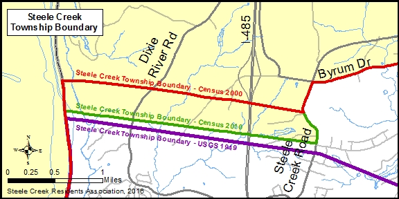
The historic Steele Creek Township boundary is difficult to pin down. The map below shows the northwest portion of the township boundary (in violet) superimposed over the Charlotte West topographic map from 1949. The current roads (in red) align well with the historic roads on the 1949 map. The township line in violet was created for use in maps on this web site by tracing the dashed township line on the topographic map.
However, the boundaries used by the United States Census Bureau for the 2000 and 2010 censuses do not line up with the boundary on the 1949 topographic map. For the 2000 census, the boundary was further north. When the Steele Creek boundary was selected for use on this web site in 2002, it followed this 2000 census boundary (in red). Before the 2010 census, the Charlotte-Mecklenburg Planning Department provided a corrected boundary to the Census Bureau, so the boundary on 2010 census maps is in a more accurate location to the south (in green). (See Steele Creek Township Shrinks, and Shrinks Some More.) Since one objective of this web site is to use a boundary that can be used to tabulate census counts, it uses the township boundary on 2010 census maps as the community boundary connecting Lake Wylie to Steele Creek Road.
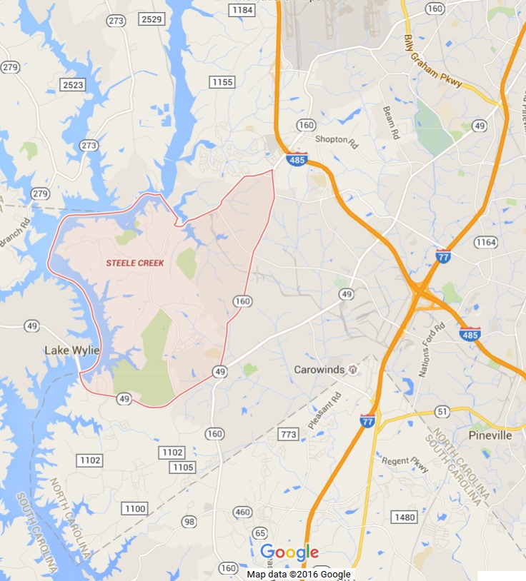
Note that boundary between North Carolina Senate Districts 37 and 38 adopted by the North Carolina General Assembly in 2011 follows the old, 2000 census boundary rather than the 2010 census boundary that was available on census maps at the time redistricting occurred. See North Carolina Senate Map. Also note that the township name in census publications was "Township 3, Steel Creek" up through the 2000 census but corrected to "Township 3, Steele Creek" for the 2010 census. Google Maps provides an erroneous boundary for Steele Creek, as shown below and in Google Maps. Some years ago the City of Charlotte, Mecklenburg County, and The UNC Charlotte Urban Institute delineated neighborhood statistical areas for use in their Quality of Life study and for other planning purposes. Although the NSAs were identified by numbers, the city decided to give them names. Unfortunately, many of the names were poor choices for the NSAs they identified. One of these was "Steele Creek," which was the name given to one part at the edge of the community. The Quality of Life Explorer no longer uses the NSAs or their names (they use census block groups), but unfortunately the damage had been done. Google Maps picked up the named neighborhoods and added them to their maps. Now if you search for Steele Creek in Google Maps, you get a map that misrepresents the actual Steele Creek community. See "Misleading Neighborhood Names" in the Steele Creek Forum. When news events happen in Steele Creek, The Charlotte Observer and other media outlets sometimes give the location as "Steele Creek" but often say the event took place in "Southwest Charlotte" or even "South Charlotte." They've even used "Southwest Charlotte" when events have occurred in the unincorporated areas of Steele Creek. South Charlotte would seem to refer to the Providence Road corridor and other areas on the other side of Pineville. Southwest Charlotte could be anywhere south and west of the Square at Trade and Tryon Streets. Steele Creek is a large enough area with a strong enough identity not to be lumped in with other parts of Charlotte. In summary:
To comment on this story, please visit the Steele Creek Forum.
|


 (April
2,
2016) Steele Creek is a community in southwest Mecklenburg County,
North Carolina. It approximates the old Steele Creek Township, which
loses territory as Charlotte annexes into it. The Steele Creek
community has a
strong self identity based on its long history. But what are it's boundaries?
(April
2,
2016) Steele Creek is a community in southwest Mecklenburg County,
North Carolina. It approximates the old Steele Creek Township, which
loses territory as Charlotte annexes into it. The Steele Creek
community has a
strong self identity based on its long history. But what are it's boundaries?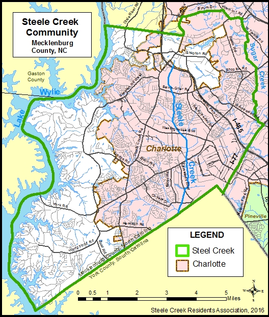
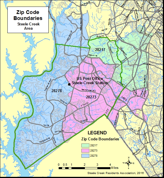
 The
US Post Office Steele Creek Station serves ZIP codes 28273 and
28278. ZIP code 28273 had been served by the Arrowood Station on
Granite Street before that station was closed. Portions of Steele
Creek also are covered by ZIP code 28217 (Starmount).
The
US Post Office Steele Creek Station serves ZIP codes 28273 and
28278. ZIP code 28273 had been served by the Arrowood Station on
Granite Street before that station was closed. Portions of Steele
Creek also are covered by ZIP code 28217 (Starmount).