|
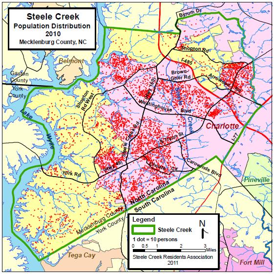
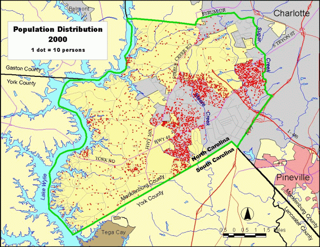
Steele Creek Population Expands Since 2000 (March 6, 2011) The 2010 census counts were released for North Carolina last week, and they show the 2010 census population of Steele Creek at 52,014, up 106% from the 2000 census count of 25,282. Mecklenburg County grew by 32% from 695,454 to 919,628, so Steele Creek has been growing at a rate three times that of the county. As the maps below show, the population has expanded into areas that were rural in 2000, and had been rural farmland for hundreds of years. The first map shows dense population in many areas in 2010 that were sparsely populated in 2000. In 2000, Steele Creek contained three densely populated areas: neighborhoods along South Tryon Street between Sugar Creek and Arrowood Road in the northeast, neighborhoods along Sandy Porter Road and Brown-Grier Road, and neighborhoods located on either side of South Tryon Street west of Steele Creek down to Erwin Road, including Yorkshire and The Crossings. For 2010, several additional areas show dense population:
Another
difference between the two maps is the extent of the Charlotte city
limits. As new development has occurred, Charlotte has annexed most
of it
into the city. However, the last major annexation was in 2007.
Charlotte will annex a small area in the Whitehall and Beam Road
areas in June 2011. See
City Council Approves Annexation in Steele Creek.
If Steele Creek were a city, it would be the 17th largest city in
North Carolina, just behind Chapel Hill (57,233), and above Burlington
(49,963), Wilson (49,167), and Huntersville (46,733), which grew by
87% since 2000, a significant increase but less than Steele Creek. That part of Steele Creek within the city limits increased from 2.9% of the city's population in 2000 to 5.9% in 2010. If city council districts are redrawn to divide the city's population into 7 approximately equal parts and the incorporated portion of Steele Creek remains in one district, it will make up about 41% of that district. The northern boundary of the Steele Creek community, as defined by this web site, follows the northern boundary of Steele Creek Township between Lake Wylie and Steele Creek Road. In 2009, Mecklenburg County reported a correction to the boundary to the Census Bureau. This correction moved the boundary southward about 1000 feet. (See Steele Creek Township Shrinks and Shrinks Some More.) As a result, the land area of Steele Creek has been reduced from 46.78 square miles to 45.96 square miles based on 2010 census geography. In the 2000 census, the population density of Steele Creek was 540 persons per square mile. For 2010, this increased to 1132 persons per square mile. The 2010 population density was 1747 persons per square mile in the portion of Steele Creek inside Charlotte and 422 persons per square mile in the area outside the city.
The population grew
rapidly in Steele Creek early in the last decade, but development
has slowed to almost a halt in the last few years as a result of the
housing crisis. Some areas remain rural, especially in the western
fringe, but likely will see new development in the future. Other areas will remain unpopulated, including McDowell
Nature Preserve and the industrial corridor along Westinghouse
Boulevard. Additionally, new residential development is unlikely in
many areas just south of the airport where airport noise and
industrial zoning will tend to make nonresidential development more
likely. |